|
|
|
|
|
|
|||||||||||||||||||||||||||||||||||||||||||||
 |
 |
|||||||||||||||||||||||||||||||||||||||||||||||||
|
Continued from Odyssey day 29 - 35 |
|||||||||||||||||||||||||||||||||||||||||||||||||
|
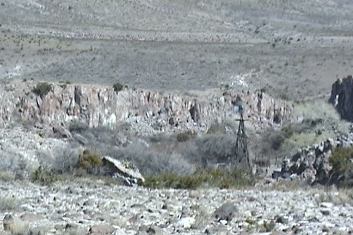
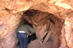
Shortly after leaving Tonuco we came to an area littered with mines, the mines lined the inside of a bowl shaped valley. The valley walls appeared to have been painted by poring red, green, white, gray and brown buckets of paint down the side of the bowl. The colors came from the different minerals in the rocks. Since the road ran along the side of the hill, in many places it was narrow and tipped toward a drop off on the left of 20 to 50 feet, that's far enough to hurt. We went about halfway around the bowl and stopped the jeeps in the road( the hillside left no room to park). From here we look back to the open end of the bowl where we entered, and beyond we see the rich green of valley farms. The green appears all the more rich for the earthen tones we are surrounded with. We then had a short walk to a mine. The mine entrance was halfway blocked by debris that had fallen down from the hill above the mine. As we stooped over to enter the mine, our trail leader told the story of when he had entered a mine and he was not paying close attention to his footing and stepped on a rattlesnake! Both he and the snake where extremely surprised. Other than some heart palpitations in both parties all survived relatively un-scathed. You better believe we all paid close attention to our footing. (Going into mines is not a smart thing to do). Once inside, the shaft was level and narrow, we had to continue walking stooped over as there was not much headroom with a lot of short pointy rocks to bang your ahead on. There was a half inch of fine dust on the mine floor, along with a spattering of rocks that had fallen from the ceiling. Sections of track for the ore carts lay strewn around at unusual angles. 30 feet into the mine was a vertical shaft going down about 10 feet deep and taking up half the floor. Walking around in a mine has a lot of obstacles to trip on! Another 20 feet ahead of us the mine was blocked by cave in (I hope we get out before there is another cave in). We carefully retrace our steps back out to the jeep's. We continued around the bowl of the valley and exited the way we came in. We headed back towards Articulation Alley. At one point we had to climb a 10 foot berm and turned left on top, the top was so narrow my tires straddle the berm and the bottom of the jeep dragged on the top. We eventually found ourselves in a sandy wash bottom. After a short while we left the sandy wash bottom and turned left when the trail ended we parked the jeeps and went for a short hike up the ravine to view the Petroglyphs. The rock formations in the ravine were quite colorful, now at the base of San Diego Mountain which means instead of sedimentary rock we now have volcanic rock. The colors of the rock are purple, red and green. Back down to the jeeps, we ate lunch. With lunch out of the way we went back to the wash and headed around San Diego Mountain, so far our wanderings have taken us about three-quarters of the way around the Mountain. On the west side of the Mountain we take a left, and the trail goes between the foothills and San Diego Mt. The trail goes past many more mines. We even drove over a mine! You can see the mine entrance below the trail and where the mine had broken the surface above the road looking like a giant rip in the surface of the earth. We parked the jeeps and went into that mine (yet again we entered a mine, boy are we slow to learn). This mine had a lot of debris on the floor, it was quite obvious that a lot of rock fallen down from the roof. You could still see timbers that the minors had put up to provide a working platform so they could get at the vein as it went up. Where they hadn't mined all the way to the surface, the ceiling collapsed so it was open to the surface now. That is the great rip that we saw from the trail. It's 50 feet from the top of the rip to the floor we were standing on. Ok, lets get out before some more of the roof falls, on us! When we get to the east side of San Diego Mt you can see the trail that goes up the face of it. It's a steep trial and covered with loose rock and sand. Up to this point a stock jeep would be able to do the trial. Now I don't know your abilities so I can't tell you what you can and cannot do. However this is certainly not the place to try alone, even with lockers some of us had a hard time getting up. Once at the top to the west we have a great view of and the Rio Grande Valley. We are in a desert so it's quite easy tell which is farmland because it's irrigated, if it's green, it's irrigated farmland. Just about due north of you about 80 miles is the Trinity site in the white sands missile range. East southeast is Las Cruces and the Organ Mountains just East of Las Cruces, these Mountains are new as they are extremely sharp and craggy. Just about do east of you, you can see a line that a fence makes across the desert. The University of New Mexico owns everything to the south of the line. The University is trying to close it for access so the only people that would be able to drive in would be scientists.
|
|||||||||||||||||||||||||||||||||||||||||||||||||
 |
|||||||||||||||||||||||||||||||||||||||||||||||||
 |
|||||||||||||||||||||||||||||||||||||||||||||||||
 |
|||||||||||||||||||||||||||||||||||||||||||||||||
|
Is this a smart thing to do? |
|||||||||||||||||||||||||||||||||||||||||||||||||
 |
|||||||||||||||||||||||||||||||||||||||||||||||||
 |
|||||||||||||||||||||||||||||||||||||||||||||||||
|
This is a lot narrower and has a much bigger crown than it looks in the picture! |
|||||||||||||||||||||||||||||||||||||||||||||||||
 |
|||||||||||||||||||||||||||||||||||||||||||||||||
 |
|||||||||||||||||||||||||||||||||||||||||||||||||
 |
|||||||||||||||||||||||||||||||||||||||||||||||||
|
Looking up at supports |
|||||||||||||||||||||||||||||||||||||||||||||||||
 |
|||||||||||||||||||||||||||||||||||||||||||||||||
|
|
|||||||||||||||||||||||||||||||||||||||||||||||||
 |
|||||||||||||||||||||||||||||||||||||||||||||||||
|
This is going up San Diego Mt. It is quite steep. |
|||||||||||||||||||||||||||||||||||||||||||||||||
|
They mined all the way up |
|||||||||||||||||||||||||||||||||||||||||||||||||
 |
|||||||||||||||||||||||||||||||||||||||||||||||||
 |
|||||||||||||||||||||||||||||||||||||||||||||||||
|
Looking West at Rio Grand valley |
|||||||||||||||||||||||||||||||||||||||||||||||||
 |
|||||||||||||||||||||||||||||||||||||||||||||||||
|
University property line |
|||||||||||||||||||||||||||||||||||||||||||||||||
|
Organ Mts behind the Dona Ana Mts just north of Las Cruces |
|||||||||||||||||||||||||||||||||||||||||||||||||
 |
|||||||||||||||||||||||||||||||||||||||||||||||||
 |
|||||||||||||||||||||||||||||||||||||||||||||||||
|
Trail up front of San Diego Mt. |
|||||||||||||||||||||||||||||||||||||||||||||||||
|
Looking towards Trinity and victory Mt |
|||||||||||||||||||||||||||||||||||||||||||||||||
|
San Diego trail map |
|||||||||||||||||||||||||||||||||||||||||||||||||
 |
|||||||||||||||||||||||||||||||||||||||||||||||||
|
Unfortunately for San Diego Mt trail all I have are the maps and my waypoints, no bread crumb trail Download Waypoints |
|
|
||||||||||||||||||||||||||||||||||||||||||||||||||||||||||||||||||||||||||||||||||||||||||||||||
|
Now as I promised the story on Dr. Voss and his golden victory Mountain. It seems that in the late 30s a Dr. Voss came home with some gold now this gold was not the Nuggets or dust that you get from mining or panning, it was molded. He never did say where he found it. Every now and then he would hike off into the Mountains and sometimes he would comeback with some more gold. He never came back with a lot of gold but, enough to take care of him and his wife's needs. I don't know how, but eventually people decided that the gold was on Victory Mountain. A lot of people tried to follow him and tried jump his claim but nobody ever did find it in. Then World War II started, the government took the land (which it was supposed to return after 20 years) for white sands missile range. Now Dr. Voss was not real happy with this, he even got arrested several times for trespassing on the white sands missile range. When he died lots of people tried to find his gold, the army had such a problem with people trespassing that they finally relented and allowed Dr. Voss wife two years to find the gold, which she never did. To this day, nobody knows where the gold is. But some people think some general went and found the gold.
|
| Hopping Jalapeno trail |
|
|
||||||||||||||||||||||||||||||||||||||||||||||||||||||||||||||||||||||||||||||||||||||||||||||||||||||||||||||||||||||||||||||||||||||||||||||||||||
|
Download track of Hopping Jalapeno trail |
|
|
|
|
|||||||||||||||||||||||||||||||||||||||||||||||||||||||||||||||||||||||||||||||||||||||||||||||||||||||||
|
Down load GPS track of Rustlers Fire Trail |
|
|
||||||||||||||||||||||||||||||||||||||||||||||||||||||||||||||||||||||||||||||||||||||||||||||||||||||||||||||||||
|
The Odyssey |
|
[Odyssey] [Day 8-14] [Day 15 -21] [Day 22 - 28] [Day 29 - 35] [Day 36 - 42] [Day 43 - 49] |
|
[the shaft] [airing down] [Salsa] [Air Compressor] [Cooking Meatloaf] |
|
[Trails] |
|
[Choke Cherry] [Holy Cross] [Death Valley] [Chili Challenge] [Caballo Mts] [Gila NF Trip] [Titus Canyon] |
|
|
||||||||||||||||||||